The Huts > Grand Huts Association > Broome Hut
Broome Hut
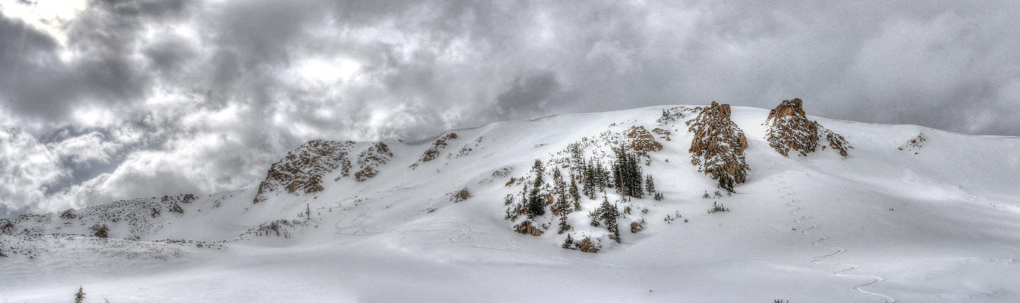
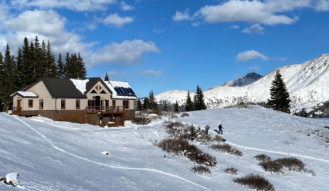
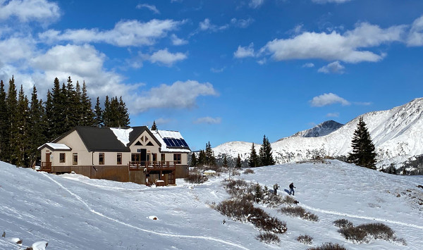
Owned and operated by the Grand Huts Association, the Broome Hut is located in the Second Creek Basin, on the west side of Berthoud Pass. At 11,350′ it is one of Colorado’s finest high-altitude skiing and hiking locales. Ease of access and great skiing make for excellent backcountry recreation opportunities. Broome Hut is family-friendly year-round.
Hut Information
Owned By
Grand Huts Association
Open
Summer / Winter
Winter Mileage*
1.0
Closest Town
Winter Park/Fraser
Hut Elevation
11,350 '
Cumulative Elevation Gain *
750'
Layout
2 bunk rooms each sleeping 6 (3 single bunk beds per room), and 2 private rooms each sleeping 2 on single mattresses (there’s a plank that can be placed between the single mattresses in each room to make a double).
Volunteer Hutmasters: GHA realizes that groups that reserve the entire hut are seeking privacy. However, GHA encourages hutmasters to stay in the self-contained, and separate day-use side. All hutmasters are expected to respect the privacy of hut guests while carrying out their maintenance duties. Guests should not be surprised to encounter hutmasters during their visit. The walls are thin, please be respectful of quiet hours!
*from Second Creek Trailhead
Amenities
Heat
Pellet
Oven
No
Refrigeration
No
Water
Cistern, Stream*, Snow Melt**
Toilet
Composting Toilet
Ada Accessible
Yes†
Sauna
No
Fire Ring
No
Grill
No
Dogs
No
Charging
None
Gear Cart
No
* Summer only
** Winter only
† Applies to the hut structure, not to route considerations
Details
- Pellets and directions for thermostat-controlled heat stove provided
- Propane for kitchen burners provided
- Coolers for food storage provided
- Large pots for melting snow on propane burners in the kitchen are provided (suggested use of snowmelt water is for drinking)
- Hand pump in kitchen dispenses water from cistern filled with roof-catchment system. Unlike cistern water at many other huts, this non-potable water can be used for drinking if filtered. Bring your own filter.
- Pots, pans, potholders, dishware, cooking and eating utensils, French press, salt & pepper
- Paper towels, dish soap, hand sanitizer, cleaning supplies, trash bags
- 2 Indoor composting toilets, toilet paper provided
- Solar powered lights
- Mattresses, pillows
- Guitars, might need strings
Book This Hut
Visit our Online Booking Platform to search for availability and book this hut.
Location
Official 10th Mountain Division Map
CalTopo
Winter Map : Grand County Hut Map
View / PrintNational Geographic
Map : Winter Park, Central City, Rollins Pass
USFS
Map : Arapaho National Forest
Trailheads/Routes
The route to the Broome Hut from the Second Creek Trailhead is approximately 1 mile, but gains almost 800 feet of elevation. Strong backcountry skills are required. Terrain in the vicinity of the Broome Hut is prone to avalanche. The hut is located at treeline and whiteout conditions and/or nightfall can make route finding difficult.
Routes
Broome Hut from Second Creek Trailhead/Standard Winter Route
Total Mileage
1.0
Trailhead Elevation
10,600'
Cumulative Elevation Gain
750'
In the summer you can get to the Broome Hut by hiking along US Forest Service Trail N137 (Second Creek Trail). This well-established summer trail leads to the hut and beyond. It is approximately 1 mile from the Second Creek Trailhead to the hut, but the trail does gain almost 800 feet of elevation so be prepared for steep, rocky sections.
No motorized access is allowed to the Broome Hut year-round. The closest a motorized vehicle can get to this hut is the Second Creek Trailhead.
There is ample hiking in the high alpine terrain around this hut. A hike up to the ridge located to the north of the hut would make for a beautiful day trip. An alternate choice would be to hike up to USFS Trail N13 (Mt. Nystrom) which follows the ridge to the west of the hut. As always, be aware of changing weather conditions and possible severe weather, including lightning events.
Summer Water Source Information
Summer Hut Information PDF
Routes
Hike on Trail to Broome Hut from Second Creek Trailhead via FS Trail N137
Total Mileage
1.0
Trailhead Elevation
10,600'
Cumulative Elevation Gain
785'
Cumulative Elevation Loss
19'

Hut-Specific Weather
Overnight : A chance of snow showers. Partly cloudy, with a low around 24. Southwest wind around 9 mph. Chance of precipitation is 30%. New snow accumulation of less than half an inch possible.
Friday : A chance of snow showers before 4pm. Mostly sunny, with a high near 41. South southwest wind around 10 mph, with gusts as high as 18 mph. Chance of precipitation is 30%.
Friday Night : Mostly clear, with a low around 31. West southwest wind 10 to 17 mph, with gusts as high as 28 mph.
Saturday : A chance of snow showers after noon. Mostly sunny, with a high near 45. West wind 17 to 22 mph, with gusts as high as 35 mph. Chance of precipitation is 40%.
Saturday Night : Mostly clear, with a low around 31. West wind 14 to 22 mph, with gusts as high as 33 mph.
Sunday : A chance of snow showers after noon. Mostly sunny, with a high near 43. Chance of precipitation is 40%.
Sunday Night : A slight chance of snow showers before midnight. Mostly cloudy, with a low around 31.
Monday : A chance of snow showers after noon. Mostly sunny, with a high near 43.
Monday Night : A chance of snow showers. Mostly cloudy, with a low around 31.
Tuesday : Snow showers likely. Mostly cloudy, with a high near 36. New snow accumulation of less than one inch possible.
Tuesday Night : Snow showers. Mostly cloudy, with a low around 26. New snow accumulation of 2 to 4 inches possible.
Wednesday : Snow showers. Cloudy, with a high near 31. New snow accumulation of 2 to 4 inches possible.
Wednesday Night : Snow showers likely. Mostly cloudy, with a low around 22. New snow accumulation of less than one inch possible.
Thursday : Snow showers likely. Partly sunny, with a high near 35. New snow accumulation of less than half an inch possible.
Contents
Notices
Avalanche Hazard Information
Colorado is known for its avalanche prone snowpack. A number of the suggested routes to 10th Mountain Division Huts pass through or are next to terrain that may be prone to avalanches. Accordingly, pick the suggested route that most suits your group and its abilities, carry appropriate equipment, and always exercise prudent backcountry travel techniques when passing through avalanche prone terrain. Remember, avalanches can occur in forested areas and can run into forested areas from open slopes. Moreover, a number of huts booked are situated in the midst of extreme avalanche terrain. Many other huts, while located in more modest terrain, still have access routes that cross avalanche paths.
We strongly suggest that someone in every group be experienced in evaluating avalanche and snow stability hazards and practicing prudent backcountry and winter mountain travel techniques. For up-to-date avalanche information for all of Colorado, visit the website for the Colorado Avalanche Information Center (CAIC). Another excellent resource is the Forest Service National Avalanche Center website. While this site doesn’t have local forecasts, it does have a wealth of information on backcountry travel in avalanche terrain and snow science, as well as tutorials on some basic skills and snow science.
We recommend that you start checking the Colorado Avalanche Information Center (CAIC) website regularly before your trip to see how conditions are evolving. Study your maps to see what type of terrain you will be traveling through to see if there are alternative routes that might be feasible if snow stability conditions deteriorate. During most of the winter, travel to the huts, other than those in the Braun Hut System and the Friends’ Hut, is possible with a relatively minor degree of risk. However, if your trip falls within a period or cycle of high or extreme instability, you must make the decision of whether or not to go. The huts are not closed for avalanche hazard reasons.