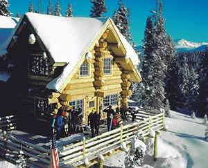
The Huts > Privately Owned > Shrine Mountain Inn > Jay’s Cabin
Shrine Mountain Inn Jay’s Cabin
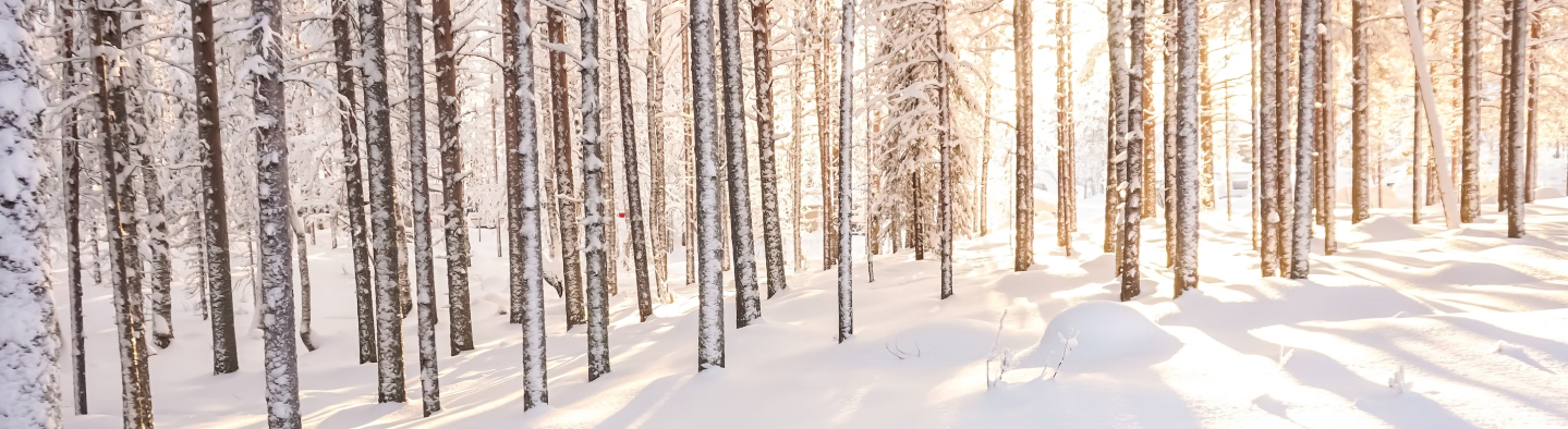
Shrine Mountain Inn sits high atop Vail Pass, nestled among the pines. At an elevation of 11,200+ feet, it offers spectacular views in every direction. An ideal first hut trip or weekend getaway, the standard routes in summer and winter to these cabins is just 2.7 miles. Whether you are drawn by the brilliant wildflowers of summer or the new powder of winter, Shrine Mountain Inn offers backcountry adventure and solitude for all.
Shrine Mountain Inn is comprised of three rustic log cabins: Jay’s, Chuck’s, and Walter’s. Jay’s sleeps 12 and can be booked by the space, Chuck’s and Walter’s are both divided in to an upstairs and a downstairs unit – each sleeping 6 – you must book all of the spaces in these units. The combined capacity of all 3 cabins is 36.
Jay’s Cabin is named in honor of Jay Utter, who purchased the land in 1960. Jay’s good friend, Chuck Anderson, is remembered by Chuck’s Cabin. Walter’s cabin is named in memory of another long-time Vail local, Walter Kirsch. All three loved these mountains, and Jay and Chuck are buried on the property in the Shrine Mountain Cemetery. The present owners not only have spent more than 40 years in the Vail Valley, but most – including Jay Utter and Chuck Anderson – either shared a background of summers in Wisconsin, growing up in Illinois, or long years of friendships in Vail. Construction of Jay’s Cabin began in the summer of 1987 and ground was broken for Chuck’s Cabin the following year. The newest of the three, Walter’s Cabin, was built in 1997. All cabins were constructed from logs cut near Eagle in the Brush Creek area and the Flattops north of Glenwood Springs.
Hut Information
Owned By
Privately Owned
Open
Summer / Winter
Winter Mileage*
2.7
Closest Town
Copper Mountain
Hut Elevation
11,223 '
Cumulative Elevation Gain *
615'
Layout
Main Level: 1 bedroom with a queen. Upstairs: 1 bedroom with a double bed, 1 bedroom with 2 single beds, 1 single bed in the hall. Downstairs: 5 single beds in a communal sleeping area.
*from Vail Pass Trailhead
Amenities
Heat
Wood, Propane Fireplace
Oven
Propane
Refrigeration
Yes
Water
Running
Toilet
Flush Toilet
Ada Accessible
No
Sauna
Yes
Fire Ring
Yes*
Grill
Yes
Dogs
No
Charging
120V
Gear Cart
No
* Summer only
Details
- Firewood, starter paper, matches, axes
- Propane for kitchen burners, oven, refrigerator, downstairs fireplace and grill on deck
- Potable hot and cold running water in kitchen and 2 indoor bathrooms
- Bathrooms have flush toilets and toilet paper, main level bathroom has bath, upstairs bathroom has shower
- Wood-fired sauna available year-round, located in separate building near Chuck’s, shared by all 3 cabins
- Firepit summer only
- Pots, pans, potholders, dishware, cooking and eating utensils, French press, salt & pepper
- Paper towels, dish soap, hand sanitizer, cleaning supplies, trash bags
- Mattresses, pillows
Book This Hut
Visit our Online Booking Platform to search for availability and book this hut.
Location
Official 10th Mountain Division Map
CalTopo
Winter Map : Camp Hale N/S Map
View / PrintNational Geographic
Map : Eagles Nest/Holy Cross
USFS
Map : White River National Forest
Trailheads/Routes
The Vail Pass area is a great place for skiers, snowshoers, snowmobilers, and other visitors to recreate in the winter. The views are spectacular, the snow is usually quite good, and the area is actively managed by the US Forest Service which generally means a better experience for all users. The most popular route for hut visitors to the Shrine Mountain Inn is via the designated non-motorized route from Vail Pass to the Shrine Mountain Inn. An alternative choice is to follow the designated multi-use route that is groomed for snowmobiles and follows the summer road platform. If using the latter, trael single file, expect and respect all users on the route. Great day trip opportunities include traveling up to Wingle Ridge, Shrine Mountain, or heading out for an out-and-back adventure on the Commando Run.
Vail Pass Winter Recreation Area Fee: This hut is located in the Vail Pass Winter Recreation Area. Use of this hut during most of the winter requires payment of additional fees to the U.S. Forest service that will be charged at the time you make your reservation. This is not a parking fee; it applies regardless of which trailhead is used. The $10.00 per person per night fee is in effect from Thanksgiving through the end of April, children 15 and under are free.
Routes
Jay's Cabin from Vail Pass Trailhead/Standard Winter Route
Total Mileage
2.7
Trailhead Elevation
10,580'
Cumulative Elevation Gain
615'
Jay's Cabin from Red Cliff Trailhead
Total Mileage
8.36
Trailhead Elevation
8,809'
Cumulative Elevation Gain
2,421'
Jay's Cabin to Vail Ski Area via Commando Run (and Reverse)
Total Mileage
16.4
Trailhead Elevation
8,220'
Cumulative Elevation Gain
5,051'
Hut to Hut/Jay's Cabin to Fowler-Hilliard Hut
Total Mileage
6.6
Trailhead Elevation
11,223'
Cumulative Elevation Gain
1,323'
Cumulative Elevation Loss
1,016'
The main summer access to the Shrine Mountain Inn Cabins is hiking, biking or driving up Shrine Pass Road to the huts. Please note though that the Shrine Pass Road is seasonally closed until June 21st each year, regardless of conditions. For a truly challenging mountain bike ride you can also try riding up the Commando Run from Vail. There are no established summer hiking trails to this hut. Vehicle access is never guaranteed to any hut at any time.
For day hiking you can follow the trail from the huts to the top of Shrine Ridge for spectacular views of the Gore Range. Mountain bikers or hikers can also take the Commando Run down into Vail, just figure out a shuttle back to the hut before you leave.
Routes
4WD High Clearance to Shrine Mountain Inn from Vail Pass via FS Road 709 (Shrine Pass Road)
Total Mileage
2.7
Trailhead Elevation
10,580'
Cumulative Elevation Gain
615'
4WD High Clearance to Shrine Mountain Inn from Red Cliff via FS Road 709 (Shrine Pass Road)
Total Mileage
9.3
Trailhead Elevation
8,809'
Cumulative Elevation Gain
2,599'

Hut-Specific Weather
Overnight : Mostly clear, with a low around 40. South wind around 6 mph.
Sunday : A slight chance of rain showers between 11am and noon, then a chance of showers and thunderstorms. Mostly sunny. High near 68, with temperatures falling to around 62 in the afternoon. North northeast wind 2 to 6 mph. Chance of precipitation is 30%.
Sunday Night : A slight chance of showers and thunderstorms before midnight. Partly cloudy, with a low around 41. South southeast wind around 9 mph. Chance of precipitation is 20%.
Monday : Showers and thunderstorms likely after noon. Mostly sunny, with a high near 68. West wind 5 to 9 mph. Chance of precipitation is 60%.
Monday Night : Partly cloudy, with a low around 40. Southwest wind around 6 mph, with gusts as high as 18 mph.
Tuesday : A chance of showers and thunderstorms after noon. Mostly sunny, with a high near 67. Chance of precipitation is 50%.
Tuesday Night : A chance of showers and thunderstorms before midnight. Partly cloudy, with a low around 41.
Wednesday : A slight chance of rain showers before noon, then showers and thunderstorms likely. Partly sunny, with a high near 67.
Wednesday Night : A chance of showers and thunderstorms before midnight. Mostly cloudy, with a low around 40.
Thursday : A chance of showers and thunderstorms after noon. Partly sunny, with a high near 66.
Thursday Night : A slight chance of showers and thunderstorms before midnight. Mostly cloudy, with a low around 41.
Friday : A chance of showers and thunderstorms after noon. Partly sunny, with a high near 66.
Friday Night : A chance of showers and thunderstorms before midnight. Mostly cloudy, with a low around 41.
Saturday : A chance of showers and thunderstorms after noon. Mostly sunny, with a high near 66.
Contents
Notices
Avalanche Hazard Information
Colorado is known for its avalanche prone snowpack. A number of the suggested routes to 10th Mountain Division Huts pass through or are next to terrain that may be prone to avalanches. Accordingly, pick the suggested route that most suits your group and its abilities, carry appropriate equipment, and always exercise prudent backcountry travel techniques when passing through avalanche prone terrain. Remember, avalanches can occur in forested areas and can run into forested areas from open slopes. Moreover, a number of huts booked are situated in the midst of extreme avalanche terrain. Many other huts, while located in more modest terrain, still have access routes that cross avalanche paths.
We strongly suggest that someone in every group be experienced in evaluating avalanche and snow stability hazards and practicing prudent backcountry and winter mountain travel techniques. For up to date avalanche information for all of Colorado, visit the website for the Colorado Avalanche Information Center (CAIC). Another excellent resource is the Forest Service National Avalanche Center website. While this site doesn’t have local forecasts it does have a wealth of information on backcountry travel in avalanche terrain and snow science, as well as tutorials on some basic skills and snow science.
We recommend that you start checking the Colorado Avalanche Information Center (CAIC) Website regularly before your trip to see how conditions are evolving. Study your maps to see what type of terrain you will be traveling through to see if there are alternative routes that might be feasible if snow stability conditions deteriorate. During most of the winter, travel to the huts, other than those in the Braun Hut System and the Friends’ Hut, is possible with a relatively minor degree of risk. However, if your trip falls within a period or cycle of high or extreme instability, you must make the decision of whether or not to go. The huts are not closed for avalanche hazard reasons.