Alert
Trips to the Braun and Friends’ Huts are a serious backcountry endeavor which demand careful planning, and the trained skills of travel and decision making in remote, avalanche terrain. These trips are not to be taken lightly even for the most experienced backcountry skier/rider. If you and your group do not have the equipment for and substantial experience with: decision making, and travel in serious avalanche terrain, and the use of navigation skills and tools in difficult conditions, choose another hut system or hire a professional guide.
Warning:
In addition to the backcountry risks described below, the Alfred A. Braun Huts and Friends’ Hut are located in areas of serious avalanche terrain with recurring avalanche cycles. Routes to and between the huts are not marked or maintained.
Avalanche Cancellation Policy:
Because the Alfred A. Braun Huts and Friends’ Hut are located in areas of serious avalanche terrain with recurring avalanche cycles, an additional opportunity to cancel due to avalanche danger exists for these huts. Groups with reservations in these huts may cancel on the scheduled day of their trip (or the next business day) if the avalanche danger is higher than what their group feels comfortable with. These groups will be given a full hut credit for a future hut trip. This credit is not transferable between huts in the Braun Hut system (including the Friends’ Hut) and huts in the 10th Mountain system. No refunds will be given at any time, for any reason. Visit Colorado Avalanche Information Center’s website: https://avalanche.state.co.us for up to date avalanche information. If you or members of your party are generally uncomfortable travelling in serious avalanche terrain, consider alternative huts in the 10th Mountain system.
Backcountry Risks:
Skiing and wilderness travel in the Elk Mountains have inherent risks, hazards and dangers that cannot be eliminated; they are very real and not to be taken lightly. People have died or been seriously injured traveling and recreating in this area. A partial list of risks, hazards and dangers a backcountry user can
encounter using these huts include:
- Hazardous mountain environments with serious avalanche terrain where avalanches occur and where additional wilderness hazards exist that may not be obvious or visible (such as cliffs, hidden streams, etc.) where weather is changeable and unpredictable and can be extreme.
- Route finding and skiing in a wilderness environment where routes and slopes are not marked, maintained, controlled or patrolled, where snow conditions vary and change, and where above tree-line travel can be extremely difficult or impossible.
- Altitude sickness and exposure, especially if your groups become lost, delayed, or separated and members do not reach the hut.
- Travel in remote areas and use of simple huts where outside help will be slow to arrive, cannot be communicated with, or is unavailable due to conditions.
- Human factors, especially those related to group decision making and perceptions of expertise and differences in physical condition and skills.
The Huts > Friends’ Hut > Friends’ Hut
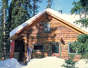
Friends’ Hut
One of the more challenging huts to access in the Elk Range, the Friends’ Hut is tucked into the edge of old growth forest beneath the south face of stunning Star Peak on the Crested Butte side of 12,700-foot Pearl Pass. This remote timberline hut is a long journey from either of the two trailheads, one at Ashcroft, south of Aspen, the other at Brush Creek, southeast of Crested Butte.
The Friends’ Hut is in memory of ten victims of a head-on collision of two small planes over East Maroon Pass in 1980 that shocked the citizens of Crested Butte and Aspen. Their deaths reached deeply into both communities and inspired this lasting tribute in the form of the Friends’ Hut, a remote, high mountain refuge linking the two towns in a spirit of friendship and common love for the mountains.
The hut was built in 1984 by scores of committed friends who volunteered endless hours and funds. Skiing to the hut entails a rigorous adventure of route-finding and avalanche preparedness.
Unlike most Colorado huts, the Friends Hut is far from any access roads. All hut supplies, including propane, are carried in for miles and our wood harvest around the hut is finite. Please help us conserve whenever possible. Thank You from the hard working Friends Hut Board.
Hut Information
Owned By
Friends’ Hut
Open
Winter
Winter Mileage*
10
Closest Town
Crested Butte
Hut Elevation
11,370 '
Layout
Friends’ Hut is a one story structure with a sleeping loft. A small room with double bed is the only private sleeping.
*from Ashcroft Trailhead
Amenities
Heat
Wood
Oven
No
Refrigeration
No
Water
Snow Melt**
Toilet
Outhouse
Ada Accessible
No
Sauna
No
Fire Ring
No
Grill
No
Dogs
No
Charging
None
Gear Cart
No
** Winter only
Details
- Firewood, starter paper, matches, axes
- Propane for kitchen burners
- Snow collection buckets and large pot for melting snow on wood-burning heat stove (bring your own filter)
- Pots, pans, potholders, dishware, cooking and eating utensils, percolator or French press, salt & pepper
- Paper towels, dish soap, hand sanitizer, cleaning supplies, trash bags, toilet paper
- Solar powered lighting
- Mattresses, pillows
- Crocs
Book This Hut
Visit our Online Booking Platform to search for availability and book this hut.
Location
Official 10th Mountain Division Map
CalTopo
Winter Map : Braun Huts Map
View / PrintUSFS
Map : White River National Forest
Trailheads/Routes
The Friends’ Hut can be accessed from either Crested Butte on the south side of Pearl Pass or from Ashcroft on the north side of Pearl Pass. When skiing in from the north side you can ski all the way into Friends’ Hut from Ashcroft in a day but many people go first to the Tagert or Green Wilson Hut for a night then over to Friends’ Hut. People also connect the Friends’ Hut with the Opa’s Taylor Hut on the south side of Taylor Pass. Be aware that the last half of the route over Pearl Pass from the north offers only a few safe travel options due to avalanche terrain and during times of high avalanche danger the route may be impassable. Traveling from Ashcroft to Friends’ Hut in a day is best done during times of low avalanche danger and good weather.
Skiing in from Crested Butte via East Brush Creek is the most common route to Friends’ Hut from the south but is still approximately 10.5 miles and crosses numerous avalanche paths along the upper part of the route.
Braun Huts & Friends’ Hut Winter Information PDF
Routes
Friends' Hut from East Brush Creek Trailhead
Total Mileage
10.5
Trailhead Elevation
8,960'

Hut-Specific Weather
Overnight : Mostly clear, with a low around 39. West northwest wind around 5 mph.
Saturday : Sunny, with a high near 63. West wind 5 to 20 mph, with gusts as high as 35 mph.
Saturday Night : Mostly cloudy, with a low around 39. West southwest wind 10 to 15 mph.
Sunday : A chance of rain showers between 9am and noon, then a chance of showers and thunderstorms. Partly sunny, with a high near 59. West southwest wind 10 to 20 mph, with gusts as high as 40 mph. Chance of precipitation is 50%.
Sunday Night : Partly cloudy, with a low around 38. West northwest wind 5 to 20 mph, with gusts as high as 35 mph.
Monday : Sunny, with a high near 60.
Monday Night : Mostly clear, with a low around 37.
Tuesday : Sunny, with a high near 63.
Tuesday Night : Clear, with a low around 40.
Wednesday : Sunny, with a high near 66.
Wednesday Night : Clear, with a low around 41.
Thursday : Sunny, with a high near 67.
Thursday Night : Mostly clear, with a low around 41.
Juneteenth : A slight chance of showers and thunderstorms after noon. Mostly sunny, with a high near 64.