Alert
Trips to the Braun and Friends’ Huts are a serious backcountry endeavor which demand careful planning, and the trained skills of travel and decision making in remote, avalanche terrain. These trips are not to be taken lightly even for the most experienced backcountry skier/rider. If you and your group do not have the equipment for and substantial experience with: decision making, and travel in serious avalanche terrain, and the use of navigation skills and tools in difficult conditions, choose another hut system or hire a professional guide.
Warning:
In addition to the backcountry risks described below, the Alfred A. Braun Huts and Friends’ Hut are located in areas of serious avalanche terrain with recurring avalanche cycles. Routes to and between the huts are not marked or maintained.
Avalanche Cancellation Policy:
Because the Alfred A. Braun Huts and Friends’ Hut are located in areas of serious avalanche terrain with recurring avalanche cycles, an additional opportunity to cancel due to avalanche danger exists for these huts. Groups with reservations in these huts may cancel on the scheduled day of their trip (or the next business day) if the avalanche danger is higher than what their group feels comfortable with. These groups will be given a full hut credit for a future hut trip. This credit is not transferable between huts in the Braun Hut system (including the Friends’ Hut) and huts in the 10th Mountain system. No refunds will be given at any time, for any reason. Visit Colorado Avalanche Information Center’s website: https://avalanche.state.co.us for up to date avalanche information. If you or members of your party are generally uncomfortable travelling in serious avalanche terrain, consider alternative huts in the 10th Mountain system.
Backcountry Risks:
Skiing and wilderness travel in the Elk Mountains have inherent risks, hazards and dangers that cannot be eliminated; they are very real and not to be taken lightly. People have died or been seriously injured traveling and recreating in this area. A partial list of risks, hazards and dangers a backcountry user can
encounter using these huts include:
- Hazardous mountain environments with serious avalanche terrain where avalanches occur and where additional wilderness hazards exist that may not be obvious or visible (such as cliffs, hidden streams, etc.) where weather is changeable and unpredictable and can be extreme.
- Route finding and skiing in a wilderness environment where routes and slopes are not marked, maintained, controlled or patrolled, where snow conditions vary and change, and where above tree-line travel can be extremely difficult or impossible.
- Altitude sickness and exposure, especially if your groups become lost, delayed, or separated and members do not reach the hut.
- Travel in remote areas and use of simple huts where outside help will be slow to arrive, cannot be communicated with, or is unavailable due to conditions.
- Human factors, especially those related to group decision making and perceptions of expertise and differences in physical condition and skills.
The Huts > Alfred A Braun Hut System > Goodwin-Greene Hut
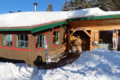
Goodwin-Greene Hut
The Goodwin-Greene is part of the Alfred Braun Hut System is located in the Elk Mountains between Aspen and Crested Butte. You can learn more about Colorado’s first hut system and how to support its work at www.braunhuts.org.
One of the most difficult to find huts, especially in a storm, the Goodwin-Greene Hut is also one of the most inspiring sites of any of the huts in the Elk Range. It is tucked away in the fold of a high, broad basin at the head of Difficult Creek beneath the escarpment of Gold Hill, which rises to the west and defines the end of Richmond Ridge.
Named in honor of two regional mountaineers, Peter Goodwin and Carl Greene, the Goodwin-Greene is often fully buried in deep snow by the time spring ski trips are popular at this remote setting. Once there, skiers have a vast, high expanse of alpine zone skiing with views into Taylor Park to the south, east to the peaks looking over Independence Pass, and north to the distant Flattops.
This hut is a long slog from the Aspen Mountain Sundeck on a one-day approach, so an overnight at Barnard Hut is often taken to break up the trip. Access from Ashcroft is also a big commitment that involves crossing avalanche chutes on Express Creek, then following posts marking the trail over windswept Richmond Ridge.
Once tucked in at the warm, concealed hut, the sun dazzles and storms rattle, and you can feel like an Arctic explorer on a distant continent.
Hut Information
Owned By
Alfred A Braun Hut System
Open
Winter
Closest Town
Aspen
Hut Elevation
11,680 '
Elevation Max*
0
Layout
Goodwin-Greene hut is a one-level structure that sleeps 10 (3 doubles, 4 singles).
Amenities
Heat
Wood
Oven
Wood
Refrigeration
No
Water
Snow Melt**
Toilet
Outhouse, Covered Walkway
Ada Accessible
No
Sauna
No
Fire Ring
No
Grill
No
Dogs
No
Charging
None
Gear Cart
No
** Winter only
Details
- Firewood, starter paper, matches, axes
- Propane for kitchen burners
- Cooler for cold food storage
- Snow collection buckets and large pot for melting snow on wood-burning heat stove (bring your own filter)
- Pots, pans, potholders, dishware, cooking and eating utensils, percolator or French press, salt & pepper
- Paper towels, dish soap, hand sanitizer, cleaning supplies, trash bags, toilet paper
- Solar powered lighting
- Mattresses, pillows
- Crocs
Book This Hut
Visit our Online Booking Platform to search for availability and book this hut.
Location
Official 10th Mountain Division Map
CalTopo
Winter Map : Braun Huts Map
View / PrintNational Geographic
Map : Aspen, Independence Pass
USFS
Map : White River National Forest
Trailheads/Routes
The Goodwin-Greene Hut is most commonly accessed by taking the Express Creek Road from Ashcroft to Taylor Pass and then roughly following the Richmond Ridge Road to the hut. This route is a beautiful ski up the Express Creek Valley and through the high alpine terrain at the end of Richmond Ridge but can be quite challenging. The ski up Express Creek Road crosses under many large avalanche paths and the last few miles over Richmond Ridge is all above treeline and offers few landmarks. During severe weather and whiteout conditions route finding can be next to impossible.
The other common route into the Goodwin-Greene Hut is from the Barnard Hut. While this route doesn’t have the same avalanche hazards as skiing in from Ashcroft, the route finding can be just as challenging.
The Alfred Braun Hut System was designed to be a back-country SKI system. As such the Alfred Braun Hut System strongly discourages the use of snowmobiles for access to the huts. The hut system was created for non-motorized travel. As such, snowmobile use can often detract from this unique experience. Our huts are located on U.S. Forest Service land, and each hut has unique travel management restrictions as governed by Forest Service Travel Management Plans. Around the immediate environs of each Alfred Braun Hut is a USFS developed recreation site envelope with snowmobile restrictions. Access to and from each hut is managed within the Developed Recreation Site Boundary. Snowmobiles should not drive to the front door of any hut. There are no snowmobile play areas within the Developed Recreation Site boundaries. Snowmobiles are not allowed in Wilderness Areas, or on private land without permission. You must know where you are if you expect to remain legal and safe. PLEASE DO NOT RELY ON A SNOWMOBILE TO GET YOURSELF OR YOUR EQUIPMENT TO A HUT.
Snowmobile Restrictions: This hut sits on a “cherry-stemmed” road surrounded by the Collegiate Peaks Wilderness Area. It is further protected by a developed hut site envelope, which begins at the saddle the road crosses above the hut, a 1/4 mile south of the hut. With the Wilderness Boundary and the terrain surrounding the hut, snowmobile travel from the ridge down to the hut is not possible without incursion into the Wilderness.
Braun Huts & Friends’ Hut Winter Information PDF
Routes
Goodwin-Greene Hut from Ashcroft Trailhead
Total Mileage
6.6
Trailhead Elevation
9,498'

Hut-Specific Weather
Tonight : Partly cloudy, with a low around 38. South southeast wind 10 to 15 mph, with gusts as high as 30 mph.
Monday : A slight chance of rain showers between 11am and noon, then a chance of showers and thunderstorms. Mostly sunny, with a high near 73. North northwest wind 5 to 10 mph. Chance of precipitation is 30%.
Monday Night : A slight chance of showers and thunderstorms before 9pm. Partly cloudy, with a low around 39. East southeast wind 5 to 10 mph. Chance of precipitation is 20%.
Tuesday : A slight chance of showers and thunderstorms after noon. Mostly sunny, with a high near 73. Northeast wind 5 to 10 mph, with gusts as high as 25 mph. Chance of precipitation is 20%.
Tuesday Night : Partly cloudy, with a low around 38. East southeast wind 5 to 15 mph, with gusts as high as 30 mph.
Wednesday : A slight chance of showers and thunderstorms after noon. Sunny, with a high near 72.
Wednesday Night : Partly cloudy, with a low around 38.
Thursday : A chance of showers and thunderstorms after noon. Mostly sunny, with a high near 76.
Thursday Night : A slight chance of showers and thunderstorms before midnight. Partly cloudy, with a low around 38.
Friday : A chance of showers and thunderstorms after noon. Mostly sunny, with a high near 73.
Friday Night : A chance of showers and thunderstorms before midnight. Partly cloudy, with a low around 39.
Saturday : A slight chance of rain showers before noon, then a chance of showers and thunderstorms. Mostly sunny, with a high near 73.
Saturday Night : A chance of showers and thunderstorms before midnight. Partly cloudy, with a low around 39.
Sunday : A slight chance of rain showers before noon, then a chance of showers and thunderstorms. Partly sunny, with a high near 71.