Trip Planning, Avalanche Information, and Backcountry Risks
Trips to the Braun and Friends’ Huts are a serious backcountry endeavor which demand careful planning, and the trained skills of travel and decision making in remote, avalanche terrain. These trips are not to be taken lightly even for the most experienced backcountry skier/rider. If you and your group do not have the equipment for and substantial experience with: decision making, and travel in serious avalanche terrain, and the use of navigation skills and tools in difficult conditions, choose another hut system or hire a professional guide.
Warning:
In addition to the backcountry risks described below, the Alfred A. Braun Huts and Friends’ Hut are located in areas of serious avalanche terrain with recurring avalanche cycles. Routes to and between the huts are not marked or maintained.
Avalanche Cancellation Policy:
Because the Alfred A. Braun Huts and Friends’ Hut are located in areas of serious avalanche terrain with recurring avalanche cycles, an additional opportunity to cancel due to avalanche danger exists for these huts. Groups with reservations in these huts may cancel on the scheduled day of their trip (or the next business day) if the avalanche danger is higher than what their group feels comfortable with. These groups will be given a full hut credit for a future hut trip. This credit is not transferable between huts in the Braun Hut system (including the Friends’ Hut) and huts in the 10th Mountain system. No refunds will be given at any time, for any reason. Visit Colorado Avalanche Information Center’s website: https://avalanche.state.co.us for up to date avalanche information. If you or members of your party are generally uncomfortable travelling in serious avalanche terrain, consider alternative huts in the 10th Mountain system.
Backcountry Risks:
Skiing and wilderness travel in the Elk Mountains have inherent risks, hazards and dangers that cannot be eliminated; they are very real and not to be taken lightly. People have died or been seriously injured traveling and recreating in this area. A partial list of risks, hazards and dangers a backcountry user can
encounter using these huts include:
- Hazardous mountain environments with serious avalanche terrain where avalanches occur and where additional wilderness hazards exist that may not be obvious or visible (such as cliffs, hidden streams, etc.) where weather is changeable and unpredictable and can be extreme.
- Route finding and skiing in a wilderness environment where routes and slopes are not marked, maintained, controlled or patrolled, where snow conditions vary and change, and where above tree-line travel can be extremely difficult or impossible.
- Altitude sickness and exposure, especially if your groups become lost, delayed, or separated and members do not reach the hut.
- Travel in remote areas and use of simple huts where outside help will be slow to arrive, cannot be communicated with, or is unavailable due to conditions.
- Human factors, especially those related to group decision making and perceptions of expertise and differences in physical condition and skills.
The Huts > Alfred A Braun Hut System > Barnard Hut
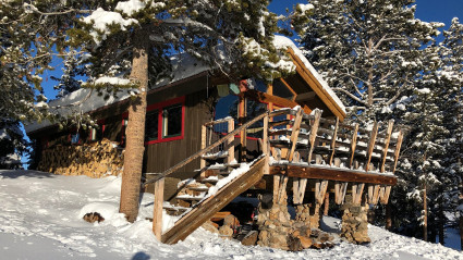
Barnard Hut
The Barnard Hut is part of the Alfred Braun Hut System is located in the Elk Mountains between Aspen and Crested Butte. You can learn more about Colorado’s first hut system and how to support its work at www.braunhuts.org.
Standing on the knoll of a forest glade on the rolling terrain of Richmond Hill, the Barnard Hut is a rustic reminder of the roots of the Braun Hut system. Built by founder Fred Braun, the hut straddles the gently undulating timbered and gladed ridge with easterly views of the Continental Divide and the Sawatch Range.
Typical access is from the Sundeck atop Aspen Mountain where skiers launch from the terminus of the Aspen Mountain gondola and follow snowmobile and snowcat tracks south along the ridge at an average elevation of 11,000 feet. Views are dramatic on this high contour, which is also popular for motorized recreation.
The Barnard is often a stopover to the more remote Goodwin-Greene Hut, further south at the head of Difficult Creek. An alternate route to Opa’s Taylor Hut is also found along the ridge beyond the head of Express Creek on an haute route traverse of the Elk Range. By this high route, Ashcroft is nine miles from the hut.
The Barnard Hut, named for past Aspen resident Marsh Barnard, may also be accessed via Little Annie Road off Castle Creek a few miles south of Aspen, though parking is an issue there. The seven-mile trek to Barnard appears straight forward on the map, but there are several descents and climbs that, at altitude, combine into a rigorous tour, which makes the site of the hut a relief to tired skiers.
Hut Information
Owned By
Alfred A Braun Hut System
Open
Winter
Closest Town
Aspen
Hut Elevation
11,480 '
Elevation Max*
0
Layout
Barnard hut is a one-level structure with loft and sleeps a total of 8 people (2 doubles, 4 singles).
Amenities
Heat
Wood
Oven
No
Refrigeration
No
Water
Snow Melt**
Toilet
Outhouse
Ada Accessible
No
Sauna
No
Fire Ring
No
Grill
No
Dogs
No
Charging
None
Gear Cart
No
** Winter only
Details
- Firewood, starter paper, matches, axes
- Propane for kitchen burners
- Cooler for cold food storage
- Snow collection buckets and large pot for melting snow on wood-burning heat stove (bring your own filter)
- Pots, pans, potholders, dishware, cooking and eating utensils, percolator or French press, salt & pepper
- Paper towels, dish soap, hand sanitizer, cleaning supplies, trash bags, toilet paper
- Solar powered lighting
- Mattresses, pillows
- Crocs
Book This Hut
Visit our Online Booking Platform to search for availability and book this hut.
Location
Official 10th Mountain Division Map
CalTopo
Winter Map : Braun Huts Map
View / PrintNational Geographic
Map : Aspen, Independence Pass
USFS
Map : White River National Forest
Trailheads/Routes
The Barnard Hut is most commonly accessed from the top of Aspen Mountain Ski area by skiing out along Richmond Ridge via the Richmond Ridge Road. The ski out is a approximately 7 miles and follows the rolling contours of the ridge. Be aware that this area is very popular with snowmobilers and various trails and tracks may intersect and branch off the main road so solid navigation skills are recommended.
The Alfred Braun Hut System was designed to be a back-country SKI system. As such the Alfred Braun Hut System strongly discourages the use of snowmobiles for access to the huts. The hut system was created for non-motorized travel. As such, snowmobile use can often detract from this unique experience. Our huts are located on U.S. Forest Service land, and each hut has unique travel management restrictions as governed by Forest Service Travel Management Plans. Around the immediate environs of each Alfred Braun Hut is a USFS developed recreation site envelope with snowmobile restrictions. Access to and from each hut is managed within the Developed Recreation Site Boundary. Snowmobiles should not drive to the front door of any hut. There are no snowmobile play areas within the Developed Recreation Site boundaries. Snowmobiles are not allowed in Wilderness Areas, or on private land without permission. You must know where you are if you expect to remain legal and safe. PLEASE DO NOT RELY ON A SNOWMOBILE TO GET YOURSELF OR YOUR EQUIPMENT TO A HUT.
Snowmobile Restrictions: This hut sits near the Richmond Ridge Road, which is open to snowmobile use from the Aspen Mountain Ski Area. The road parallels the Collegiate Peaks Wilderness boundary, which lies east of the road. There is a Developed Hut Site Boundary envelope in the immediate vicinity of the hut. Of all the Braun Huts, this is the hut at which you are most likely to encounter snowmobiles along the Richmond Ridge Road. Snowmobiles are not allowed at the hut itself.
Braun Huts & Friends’ Hut Winter Information PDF
Routes
Barnard Hut from Top of Aspen Mountain (Sundeck Restaurant)
Total Mileage
7.2
Trailhead Elevation
11,212'

Hut-Specific Weather
This Afternoon : A chance of showers and thunderstorms before 5pm, then scattered showers and thunderstorms. Mostly cloudy, with a high near 76. Northwest wind around 5 mph. Chance of precipitation is 60%.
Tonight : Scattered showers and thunderstorms before 10pm. Mostly cloudy, with a low around 49. Southeast wind around 5 mph. Chance of precipitation is 40%.
Wednesday : A chance of rain showers between 10am and noon, then showers and thunderstorms likely between noon and 3pm, then showers and thunderstorms likely. Partly sunny, with a high near 69. West wind 0 to 5 mph. Chance of precipitation is 70%.
Wednesday Night : A chance of showers and thunderstorms before 9pm, then a chance of showers and thunderstorms between 9pm and 11pm, then a slight chance of showers and thunderstorms between 11pm and midnight. Partly cloudy, with a low around 47. South southeast wind 0 to 5 mph. Chance of precipitation is 50%.
Thursday : A chance of showers and thunderstorms after noon. Mostly sunny, with a high near 68. West northwest wind 0 to 10 mph, with gusts as high as 25 mph. Chance of precipitation is 30%.
Thursday Night : Mostly clear, with a low around 48.
Friday : Sunny, with a high near 70.
Friday Night : Mostly clear, with a low around 49.
Saturday : Sunny, with a high near 73.
Saturday Night : Mostly clear, with a low around 50.
Sunday : Sunny, with a high near 73.
Sunday Night : Partly cloudy, with a low around 51.
Monday : A chance of showers and thunderstorms after noon. Mostly sunny, with a high near 72.
Monday Night : A slight chance of showers and thunderstorms before midnight. Partly cloudy, with a low around 48.